IMCA Insights – March 2012
The Mysterious Hico Structure,
Hamilton-Erath Counties, Texas
by Paul V. Heinrich
Within Texas, credible
proposals have been made for the extraterrestrial impact origin of six
geological structures. Convincing cases have been made for three of
these structures, i.e. Marquez structure (Leon County), Odessa crater
(Ector County), and Sierra Madera (Pecos County), of being of impact
origin (Gibson 1990; Littlefield et al. 2007; Howard et al. 1972;
Wilshire et al. 1968; Wong 2001). The Bee Bluff structure in Zavala
County, Texas, is disputed (Sharpton and Nielsen 1988; Jurena et al.
2001). Another proposed Texas impact structure, the Wilbarger structure
in Wilbarger County, has been discredited by detailed field research
(Nelson 2006). The origin of the last of these structures, the Hico
structure, which lies in Hamilton-Erath County, remains an unresolved
mystery.
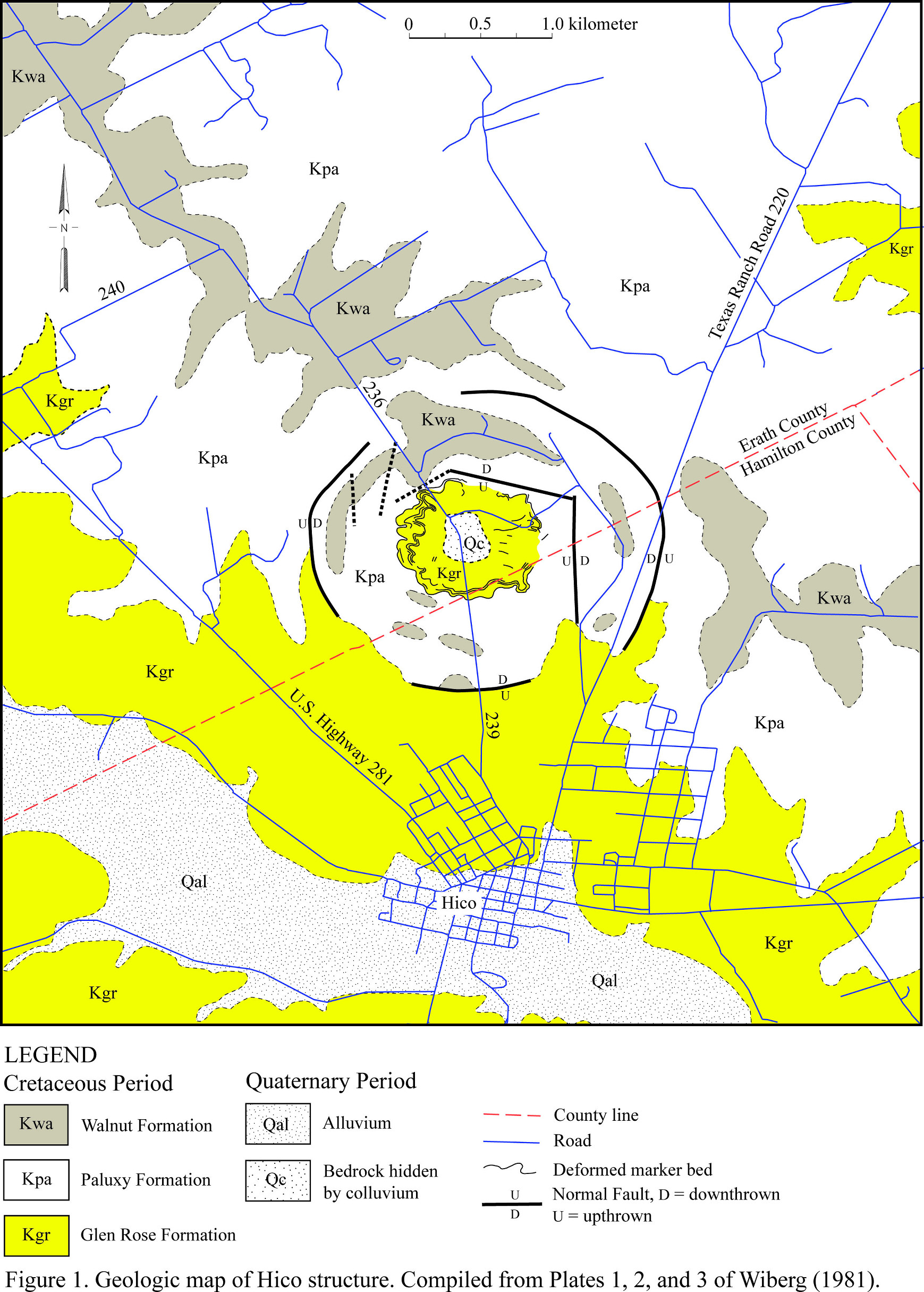
The Hico structure is a circular disturbance that is developed in Lower
Cretaceous strata, upper Glen Rose, Paluxy, and lower Walnut formations
about 3 km (1.8 miles) north of Hico, Texas and 32.085 degrees north
latitude and 98.0342 degrees west longitude. On aerial photographs, it
appears as a circular feature about 3 km (1.8 miles) in diameter (see
map). The arc segments comprising this anomaly consists of tree lines
and drainages associated with ring-like troughs, which encircle the
central uplift of the Hico structure. On Landsat imagery, the Hico
structure is at the center of a subtle 9-km (5.5-mile) in diameter
circular feature (Wiberg 1981, 1982; Milton 1987).
Map of the Hico
structure, Hamilton-Erath Counties, Texas
(Click the image to open a high-res map in a new window)
History
Mr. William J. McBride first discovered the Hico structure in 1953 while
mapping the geology of Hamilton County for Humble Oil and Refining
Company. In 1956, they drilled the center of this structure looking for
oil and gas. Unfortunately, well logs and other data acquired during the
drilling of this well and McBride’s original report were lost in a
warehouse fire (Wiberg 1981). If copies either of the report, well logs,
seismic sections, and other data were archived elsewhere and survived
the fire and could be located, they might provide invaluable data
concerning the origin of the Hico structure.
Later, Mr. Oscar Monnig, a Fort Worth meteorite collector and amateur
astronomer, pointed out this enigmatic structure to Dr. James R.
Underwood, who at the time was a professor for West Texas State
University, as a potential impact structure. Later, Dr. Underwood
suggested to Ms. L. Wiberg that the Hico structure would be a suitable
subject of study for a master’s thesis at Texas Christian University.
This research yielded Wiberg (1981, 1982) and Milton (1987).
Approximately twenty years after Wilson (1981, 1982), Heggy et al.
(2004) examined the Hico structure using ground penetrating radar and
analysis of SRTM Digital Elevation Model.
Local Geology
The bedrock, in which the Hico structure has developed, consists
predominately of nearly horizontal, Lower Cretaceous marls, limestone,
and sandstone, which dips about 3.5 m per km (18.5 ft per mile) towards
the southeast (Figure 1). The oldest strata exposed within the vicinity
of the Hico structure is 24 m (79 ft), which belongs to the upper Glen
Rose formation, of micritic and fossiliferous limestone alternating with
resistant beds of marls. Overlying the Glen Rose Formation is 15 to 20 m
(49 to 66 ft) of reddish brown, friable sandstone, which contain
hematite concretions, of the Paluxy Formation. Some 40 m (130 ft) of the
lower and middle Walnut Formation, which consists of calcareous clays
and thin-bedded limestones overlies the Paluxy Formation and outcrops in
the vicinity of the Hico structure. Both the Paluxy and Walnut
formations contained distinctive limestone and sandstone marker beds,
which were used to map the deformation of strata within the Hico
structure in detail (Wiberg 1981; Milton 1987).
Structure
As interpreted by Wiberg (1981, 1982) and Milton (1987), the Hico
structure consists of a circular feature, about 3 km (1.8 miles) in
diameter, consisting of a central uplift and a ring graben (Figure 1).
In addition, they noted that the Hico structure lies at the center of a
subtle 9-km (5.5-mile) in diameter circular feature of uncertain origin.
The central uplift of the Hico structure, as illustrated by Wiberg
(1981) and Milton (1987), consists of outer and medial zones of
circumferential folding surrounding the center of the structure, which
is hidden by colluvial deposits (Figure 1). The outer zone of folding
consists of open, undulating “pie-crust” folds, which are defined by the
marker beds recognized by Wiberg (1981). Towards the center of the
feature, these folds become tighter to form a medial zone of chevron
folds with axes radial to center of the Hico structure. These folds
consist of vertical or near-vertical beds of Glen Rose limestone.
Holocene and Quaternary colluvial deposits blanket the center of the
central uplift. As result, neither the age nor the structure of the
rocks comprising the center of this structure is known. Wiberg (1981)
and Milton (1987) suspects that the bedrock within the center consist of
Pennsylvanian age sandstones of the Twin Mountain Formation, which have
been uplifted by as much as 80 m (260 ft) (Wiberg 1981, 1982; Milton
1987).
Wiberg (1981, 1982) and Milton (1987) argue that a ring graben surrounds
the central uplift. They concluded that the outer boundary of this ring
graben is defined by a series of major faults, which are part of a ring
fault (Figure 1). The inner boundary of this graben consists of numerous
obscured faults, which have small displacement ranging from 8 to 18 m
(26 to 59 feet). Within the ring graben, erosional outliers of Walnut
Formation have been downfaulted into Paluxy and Glen Rose Formation.
Although largely obscured by alluvial and colluvial deposits,
circumferential folding also appears to be present within the ring
graben (Wiberg 1981, 1982; Milton 1987).
Wiberg (1981) reported observing a subtle 9-km (5.5-mile) in diameter
circular feature, within which the Hico structure lies at it center, in
Landsat imagery. She was unable to find a geological explanation for
this feature.
Later, Heggy et al. (2004) examined the Digital Elevation Model (DEM)
constructed from the Shuttle Radar Topography Mission (SRTM) data. They
found three previously unrecognized topographic rings, of which the
outermost one is 5 to 6 km (3 to 3.7 miles) in diameter. Ground
penetrating radar study of these rings indicated that these rings are
controlled by ring faults similar to those that form the outer boundary
on the ring graben.
They concluded that the outermost ring represents the true diameter of
the Hico structure. They make no mention of the 9-km (5.5-mile) in
diameter feature observed by Wiberg (1981).
Evidence of Shock Metamorphism
Wiberg (1981) collected samples of a marker bed composed of
calcite-cemented sandstone from outcrops of folded Paluxy Formation
exposed in the central uplift of the Hico structure. Powered samples of
this sandstone were analyzed using x-ray diffraction. No indication of
coesite, a high-pressure form of quartz created by extraterrestrial
impacts, was found in these samples. She also prepared samples of
sandstone and limestone from the folded strata from the central uplift.
She found a lack of any evidence of shock metamorphism in either the
sandstone or limestone samples (Wiberg 1981, 1982; Milton 1987).
Milton (1987) examined two borrow pits exposing friable limestone of the
Glen Rose Formation within the central uplift. In one borrow pit, she
found surfaces exhibiting convergent striations. Although the striations
are irregular due the friable nature of the limestone, they were
interpreted by Milton (1987) to be shatter cones.
Geophysical Surveys
Wiberg (1981) acquired gravity and magnetic data along transects across
the Hico structure. Analyses of this geophysical data revealed neither
gravity nor magnetic anomalies associated with its central uplift. She
did find weak Bouger gravity anomalies associated with the ring faults
associated with the ring graben (Wiberg 1981, 1982; Milton 1987).
Discussion
According to the Spray and Hines (2007), the principal criteria for
determining if a geological feature is an impact structure formed by the
hypervelocity impact of a meteorite or comet are (1.) presence of
shatter cones, (2.) presence of shocked quartz with multiple planar
deformation features within in situ minerals, (3.) presence of
high-pressure mineral polymorphs within in situ minerals, (4.)
morphometry of the structure, (5.) presence of an impact melt sheet
and/or dikes, and impact melt breccias, and the presence of impact
pseudotachylyte and breccias associated with radial and concentric fault
systems. So far in terms of these criteria, only the morphometry of the
Hico structure and report of shatter cones by Milton (1987) having been
found in a borrow pit appear to meet these criteria. Unfortunately,
Milton (1987) provides neither the detail descriptions nor photographs
needed to document the occurrence of shatter cones. As a result, the
existing published evidence is inadequate and insufficient to
demonstrate the existence of shatter cones associated with the Hico
structure.
The morphometry of the Hico structure is generally regarded as
insufficient proof of its impact origin. Unfortunately, circular
terrestrial structures, e.g., volcanoes, salt diapirs, glacigenic
features are generated by numerous other means, so the Hico structure’s
circular morphometry is not sufficient to prove impact structure status.
However, as discussed by Wiberg (1981, 1982) and Milton (1987), the
internal structure, which includes a ring graben and central uplift, of
the Hico structure is quite similar to known impact structures. This and
the lack of any plausible non-impact mechanisms for its origin, strongly
indicate, but do not prove, that it is an extraterrestrial impact
structure.
Conclusions
Although conclusive evidence for the extraterrestrial impact origin of
the Hico structure is still yet to be found, it appears that it is quite
likely an extraterrestrial impact structure. The search for definitive
evidence of shock metamorphism associated with the Hico structure is
still incomplete and more research needs to be done. First, the identity
of the bedrock underlying the center of this structure still needs to be
determined. Finding uplifted and deformed Pennsylvanian bedrock beneath
the colluvium covering the center of this structure will greatly
strengthen the case for the impact origin of this structure. In
addition, it is within the strata underlying the center of the Hico
structure where the best chance for finding shocked quartz exists.
Finally, the shattered cones reported by Milton (1978) need to verified
and better documented before they can be accepted as proof of the impact
origin of this structure.
In addition, another unanswered question is the significance of the 9 km
in diameter feature reported by Wiberg (1981). The existence and origin
of this circular feature was completely ignored by Heggy et al. (2004)’s
investigation of smaller circular features. Whether it is real, how it
formed, and what is its relation to the Hico structure remains an
unresolved mystery.
Paul V. Heinrich
Louisiana Geological Survey
Louisiana State University
Baton Rouge, LA 70803
Acknowledgments
I thank Douglas Carlson, Assistant Professor of Research, Louisiana
Geological Survey for taking the time to review this article and his
advice on how to improve it.
References Cited:
Littlefield, D. L.,
P. T. Bauman, and A. Molineux. 2007. Analysis of formation of the Odessa
crater, International Journal of Impact Engineering, v. 34, pp.
1953–1961.
Gibson, J. W. 1990. Marquez Dome - an impact in Leon County, Texas.
Unpublished M.S. thesis, University of Houston, Houston, Texas, 65 p.
Heggy, E., F. F. Horz, A. Reid, S. A. Hall, and C. Chan. 2004. Potential
of radar imaging and sounding methods in mapping heavily eroded impact
craters: mapping the Hico Crater. 35th Lunar and Planetary Science
Conference, abstract no. 1462, Lunar and Planetary Institute, Houston,
Texas. http://www.lpi.usra.edu/meetings/lpsc2004/pdf/1462.pdf, 224 KB
PDF file, last visited on September 28, 2007.
Howard, K. A. T. W. Offield, and H. G. Wilshire. 1972. Structure of
Sierra Madera, Texas, as a guide to central peaks of lunar craters.
Geological Society of America Bulletin, v. 83, pp. 2795–2808.
Jurena D., B. M. French, and M. J. Gaffey. 2001. Planar Deformation
Feature Orientations and Distribution in Quartz Grains from the Carrizo
Sand Formation in South Texas: Relation to the Bee Bluff Structure.
Lunar and Planetary Science XXII abstract no. 1828. Lunar and Planetary
Institute, Houston, Texas.
Nelson, J. 2006. personal communication, November 2006, Illinois State
Geological Survey, Champaign, Illinois.
Milton, L. W.. 1987. The Hico impact structure of north-central Texas.
in pp. 131-140, J. Pohl, ed., Research in Terrestrial Impact Structures.
University of Munchen, Munich, Federal Republic of Germany.
Sharpton, V. L., and D. C. Nielsen. 1988. Is the Bee Bluff structure in
South Texas an impact crater? In Lunar and Planetary Science XIX. Lunar
and Planetary Institute, Houston, Texas. pp. 1065-1066.
Spray, J., and J. Hines. 2007. Earth Impact Database.
http://www.unb.ca/passc/ImpactDatabase/index.html, last visited on
September 28, 2007.
Wiberg, L. 1981. The Hico Structure; a possible astrobleme in
north-central Texas, U.S.A. Unpublished M.S. thesis, Texas Christian
University: Fort Worth, Texas, 75 p.
Wiberg, L. 1982. The Hico Structure: a Possible Impact Structure in
North-Central Texas, USA. 13th Lunar and Planetary Science Conference,
Lunar and Planetary Institute, Houston, Texas, p. 863-864.
Wilshire, H. G., and K. A. Howard. 1968. Structural patterns in central
uplifts of cryptoexplosion structures as typified by Sierra Madera.
Science, v. 162, p. 258-261.
Wong, W. A. 2001. Reconstruction of the subsurface structure of the
Marquez impact crater in Leon County, Texas, USA, based on well-log and
gravity data. Meteoritics & Planetary Science, v. 36, no. 11,
p.1443-1455.
This
article is a re-print from the Houston Gem and Mineral Society
Bulletin,
and it is published with permission.
•
IMCA Home Page •
IMCA Code of Ethics •
IMCA Member List
•
Join IMCA •
IMCA Meteorite Info